There were four roads that we used to get to our log home in the Rockies. We had our own names for these roads as they didn’t have anything but forest service numbers on a topographical map when we lived at 9,640 feet above sea level.
Columbine Campground road was the most direct, but the bumpiest. It required either a 4-wheel drive or a good truck with 2-wheel and an experienced driver. This road was a continuation of the road to the campground itself. Mostly we only traveled that road out of necessity when there wasn’t another option. Since then, the road has been blocked off to prevent more damage to the forest.
The ‘spring’ road was fairly level and meandered by a lush meadow with a claw foot bath tub sitting just inside a barbed wire fence. Into the tub poured a fresh, cold spring through an iron pipe coming out of the ground. We often stopped to fill up when we were empty at home. That water was the best mountain spring water ever. Spring road did have a very steep climb at the end, but a tenacious driver of a 2-wheel drive car or truck could handle it.
The most out of the way road is Fall River Road. This was used when the other roads were impassable. This one at least got you to the base of Mt. Pisgah, even if we did live on the other side. It was also the road we used if we had reason to go to Idaho Springs.
But the most passable road with the least overall elevation changes is Bald Mountain Road. It was on this road that I learned to steer for my dad while we drove back and forth to our property building our cabin. Later it became the road I drove the most to get to and from Central City when I was old enough to drive and had my own car.
Bald Mountain road can be found as a dirt road off of the annual Aspen Trail. Travel either direction from Central City to find it going off into the trees on the edge of King’s Flat.
While I already had driven the Jeep, the trucks, the motorcycles and the snowmobiles, my first car was a charcoal black 1970 Volkswagen Beetle. After I got my license by driving around a few blocks in the ‘city’ I was able to go to and from home whenever I wanted. Mostly it was to work at either the home of the elderly woman I mowed grass and did odd jobs for, or to my first real job as a sanitation engineer in BlackHawk.
Work allowed me to spend money on things I wanted. Like a sweet Sony car stereo with cassette and auto-reverse. I added some nice Pioneer speakers to the back and found room for amplifier with EQ in the glove compartment. To be truthful, one of the main reasons I drove Bald Mountain road was because it as the smoothest and didn’t skip my cassettes. Yes, it was actually possible to skip them.
So Bald Mountain road it was, I left the city behind, usually took the switchback by the ranch, through King’s Flat and headed off into the woods.
Pretty easy going in the beginning and it looks like it is fairly well maintained. That is until you get to the very small cemetery. Once you pass the entrance to the old cemetery you have to cross a cattle guard and make your way over some permanent bedrock. As long as you pay attention your car doesn’t bottom out.
The way then becomes flat and pretty wide; obviously not maintained very well. Smooth driving across the sandy part of the road avoiding nuisance rocks every once in awhile.
The first big obstacles appear, this is another set of rocks that are just embedded in the middle of the road. I just drive around the big rocks and continue on my way.
Next up, a big pair of puddles from the recent rain. They are larger than my car, but I’m familiar with them, I know how deep they are and can just drive between them or around them.
The way continues like this with smaller rocks that I just avoid by steering around them, larger rocks that I drive around completely, and puddles that I know well. In the cooler temps the water has a thin layer of ice on it and breaks as I drive through it.
Now we round a bend on the inside of Bald Mountain and pass the property of one of my dad’s many friends. He met Tom M because he saw him creating a very steep driveway up to his property. He and his family were building at the top of the hill. The driveway was so steep that he had to have an old Army Jeep to get up the mountain.
More of the relatively easy driving around the side of the mountain. This is why I drive this road home. So relaxing with the sun coming through the trees, a light breeze coming through my open window and “the Clash” or “Kajagoogoo” blasting on the stereo.
We have come around the mountain now (so to speak), what was previously a drop off with mixed trees has become flat with sparser trees. The spacing between them allows a better view of plentiful wildlife.
A fork in the road presents a choice. To the left, the dirt road connects to York Gulch Road. The forest service road that runs down York Gulch and connects to Fall River Road and then to I-70 and finally Idaho Springs where the Safeway was.
To the right was home. Not much further through the younger pine and we reach another road coming in sharply from the left. This road too leads to York Gulch after connecting to the earlier road going there and thereby forming a very large triangle between.
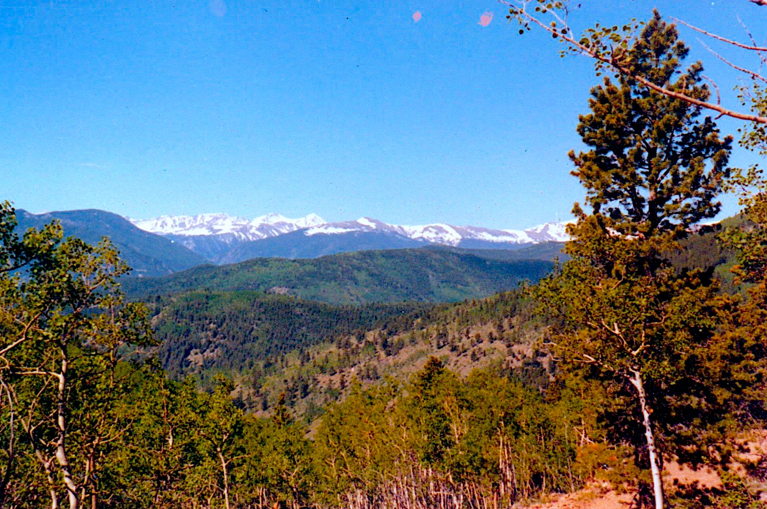
We come to a “saddle” between the mountains. I learned this land-form from my dad, not geography class.
To the right, and sharply downhill is the end of “spring road”, where it is at the steepest grade.
To the left, this view.

You may recognize it as the landing page photo for this site. The photo was taken by my father, Douglas Gibbins.
Continuing on though, around the side of Mt. Pisgah, the road has gotten much, much rockier. Some areas of the road have become bedrock instead of dirt. Then, as the road becomes steeper, I drive on the large rocks which are now a part of the road. Far below to the right is the pasture with the bathtub spring mentioned before.
My little car finally crests the hill. This time of year this area is dry, but during spring run-off there would be two very, large puddles to traverse here. I drive directly through what looks like the very, small, very deep, dry lakes that are twice the width of my Volkswagen. In the spring the water would have gone up past my floorboards and I would have had to carefully navigate around the side of them.
This is an area frequented by drivers of 4x4s. Some alone or with their families, and a whole lot of others in clubs come up from the flatlands on the weekends. When the water is real deep they make roads through the Columbine filled, old Aspen grove to get to the “other side”.
For me, the other side meant intersecting with Columbine Campground road going downhill to the right. I continued to the left hugging the side of Mt. Pisgah on my left. A slight gradient continues with a composition of dirt interspersed with bedrock. Nothing worse than what I’ve already driven over.
In case you were wondering the Sony stereo is playing just fine and will all the way home.
At the top of the hill now, various roads converge as the 4x4s have made their own way up the hill through the meadow below. To the left is Pisgah Lake or Lake Pisgah or just a large mud hole depending on the season and who you talk to. Someone is building a cabin not too far from the lake, but you can’t see it through the trees.
Slightly uphill and to the right now I pass through an area that in the winter time is completely covered in a drift. Another path can be seen uphill that drivers use in the winter time to go around it.
Shortly the road continues to the left, but also goes straight. Following it straight through brings you to a large clearing, then straight up the side of a mountain. Joe and Emily lived on the other side of that mountain and we used to drive their 1942 Dodge ambulance right up Lloyd Hill, park on the top and walk down to their cabin. Calling it Lloyd Hill was some private joke between my father and Joe. He was in a local band and I think it had to do with the band name.
Our cabin was further down the left road though. I take the low road instead of the high one used in winter. After driving, I see a road going steeply up to the right where it will meet the others going up Lloyd Hill.
Directly ahead is a sharp turn in the road where it literally comes around the mountain. It was from this point that anyone in our cabin could hear the oncoming vehicles very clearly. As they came around curve the sound carried all the way up Hamlin gulch. Mom could easily identify my VW, our Jeep, the trucks, the snowmobiles and the motorcycles.
The next part of the trek was one of the hardest in the winter. Mom used to say we had three seasons: July, August and Winter. This portion of the road was actually cut into the side of the hill. During the deepest part of the winter the entire road is obscured by a huge drift that fills in the entire section. Several 4×4 roads lead way uphill to the right through the Aspen, then lead back down once the end of the drift was reached.
This excursion though takes place in July or August. The roads are dry and access to our cabin is easy. I continue through on the actual road, then pass the smaller one leading up to the cabin that was built by another family who later became friends. Jerry and Susan had three boys all beginning with the letter “R”. The older boys walked to to school with us many, many times.
Now the final stretch to our log cabin. This part is narrow with trees closing in on both sides. The snow doesn’t drift here due to the trees, but it falls and stays for the season. If you look closely at some of the largest pines, you can see the scars left at the bases from the winch on our Jeep.
Once past this patch the road is level and in the winter, pretty clear. Today I smoothly drive around the bend past the old cattle/deer path that crosses here and leads down past our outhouse and the then corner of our basement door.
If I feel like driving down our ridiculously steep driveway or am carrying family groceries, I turn and drive slowly down the grade in first gear. Turning left and over a culvert I pull up under the large pine next to the house.
Sometimes I just park at the top and walk down the well worn path. It always led to warmth and love.